


Langtang National Park is the closest major Himalayan trekking destination to Kathmandu. The park rises from 1,000 m in its subtropical lower forests to 7,234 m at the top of Langtang Lirung.
It spans 1,710 sq km across three districts (Rasuwa, Sindhupalchok, and Nuwakot) and is home to 46 species of mammals, over 345 species of birds, and more than 1,000 species of vascular plants within those boundaries.
On this 10-Day Classic Langtang Valley Trek, you enter Rasuwa via Nuwakot and go through a forested route, walk along the Langtang Khola river, and enjoy nature in the best way possible!
In fact, this is our most complete format for the Langtang region and also the most popular package on this route.
The reason is straightforward: it handles everything from the moment you land at Tribhuvan International Airport to the moment you head back, so there are no loose ends to manage independently. You arrive and enjoy Langtang while we take care of the rest!
The 10 days of your Nepal trip break down like this:
- Day 1 is your airport arrival and trek briefing.
- Day 2 is a guided full-day exploration of 4 UNESCO World Heritage Sites in Kathmandu Valley.
- Day 3 begins the drive to Syaphru Bensi and the first walk to Bamboo.
- Days 4 to 8 cover the full Langtang circuit, from the river trail to Kyanjin Gompa and both the Kyanjin Ri sunset hike and the Tsergo Ri or Tserko Ri (4,985 m) summit.
- Day 9 is the drive back to Kathmandu and a traditional Thakali cultural dinner.
- And Day 10 is your airport departure.
So, at USD XXX per person, you’re getting the complete Langtang Valley Trail, both high-altitude summit hikes, 2 nights in Kyanjin Gompa, a Kathmandu cultural day, and a celebratory dinner at the end. We promise: this package does not leave anything important out!
Having doubts? Well, go through the full package content before you hit that BOOK NOW button. We’ve shared the complete itinerary and route details, along with breaking down every attraction below to help you get a complete picture of what to expect across all 10 days.
Who Should Choose This Package?
This 10-day format of Langtang Valley is honestly one of the best treks in the Langtang region and remains a perfect choice for anyone wanting the complete experience without having to manage any of the logistics parts yourself. Here is precisely who it works best for:
- Those visiting Nepal for the first time and want a fully organized trip. From your airport pickup on Day 1 to your departure drop-off on Day 10, our team handles transport, accommodation, permits, guides, porters, and briefings. You focus on the experience, not the logistics.
- Trekkers who want a Kathmandu cultural experience included before the trek. The Day 2 guided tour of 4 out of 7 UNESCO World Heritage Sites is one of the most valuable parts of this package. Many first-time visitors try to rush Kathmandu on their own, miss the context, and arrive at the mountains without understanding what they are trekking through. Our Day 2 tour changes that!
- Those with a fixed 10-day window who want the full Langtang experience. This itinerary is designed around a set schedule with consistent daily distances. It does not rush any single day, and every stop from Bamboo to Kyanjin Gompa gives your body the time it needs to adjust to Langtang’s altitude progressively.
- Trekkers who want both Kyanjin Ri and Tsergo Ri without compromise. Some shorter itineraries force you to choose one or skip both due to timing. This 10-day format dedicates Day 5 to the Kyanjin Ri sunset hike and all of Day 6 to the Tsergo Ri summit, so neither hike gets rushed.
- Those who are just starting out on trekking in the Himalayas. The gradual daily elevation gain, the two nights in Kyanjin Gompa, and the guide who monitors you throughout make this format genuinely safe for people who have never been above 3,000 m. The only challenging days are Days 5 and 6, and both are manageable with basic fitness preparation.
- Groups with mixed fitness levels. Because no single day is excessively long or rushed, and because the Tsergo Ri hike on Day 6 can be modified or skipped based on individual condition, this format accommodates people with different physical capabilities on the same trip.
Main Stops and Villages Along the Route
This trek follows a linear out-and-back trail from Syaphru Bensi, reaches deep into Langtang Valley, and the return is the same route!
Full Route: Kathmandu > Syaphru Bensi > Bamboo > Thangshyap > Kyanjin Gompa > Kyanjin Ri > Kyanjin Gompa > Tsergo Ri > Kyanjin Gompa > Lama Hotel > Syaphru Bensi > Kathmandu
Here is what you need to know about each overnight stop on this itinerary:
- Kathmandu (1,317 m): Your first 2 nights and final night of the trip are here, all at a 3-star hotel (usually in Thamel, often known as the main tourist hub of Kathmandu). On Day 1, this is your recovery night after the flight. On Day 2, it is your base for the UNESCO heritage tour. And on Day 9, it is where the Thakali cultural dinner and trek completion certificate presentation happens. Thamel itself is worth walking in the evenings and is well-known for its nightlife too!
- Bamboo (1,984 m): The name gives it away! The lower trail from Syaphru Bensi passes via Tiwari, Domen and through dense bamboo groves mixed with oak, alder, and rhododendron before reaching this small settlement sitting right on the Langtang Khola riverbank. The sound of the river from your bed on the first night is something that our prior guests have consistently mentioned. The forested trail between Syaphru Bensi and Bamboo is also one of the best sections for red panda sightings, particularly at dusk in the bamboo zones.
- Thangshyap (3,140 m): This stop is what separates a well-paced 7 days from the rushed 5-day or 6-day versions that push to Langtang Village on the same day. By stopping here instead of going further, you keep Day 4 to a manageable 11 km and 1,160 m of elevation gain, and your body crosses the 3,000 m threshold gradually rather than in a single push. Thangshyap is basically a small settlement, with just a few teahouses, but that also means it is quieter than the more popular overnight stops.
- Kyanjin Gompa (3,890 m): This is the best stop on your entire 10-day Nepal tour, honestly. And to complement that, we have added 2 full nights here, which is the only way to do both Kyanjin Ri and Tsergo Ri properly. The village is surrounded by peaks on all three sides, with Ganchenpo stealing the spotlight in front and Lower Kyanjin Ri right above your head! It’s also home to the oldest monastery in the upper Langtang valley, Organic Yak Cheese Production Centre, Lirung Glacial Lake, local bakery cafes, etc.
- Lama Hotel (2,515 m): Originally called Changdam village, this settlement got its current name from a small lodge run by a local lama in the early days of Langtang trekking. Early foreign trekkers started calling it Lama Hotel, and the name stuck. On the ascent, this is a lunch stop on Day 4. On the descent, it is your overnight stop on Day 7, and the significant drop in altitude from Kyanjin means you breathe easily here, sleep well, and usually feel your appetite return properly for the first time since Day 5. Moreover, the riverside setting is similar to Bamboo, and the Langtang Khola is right beside you again!
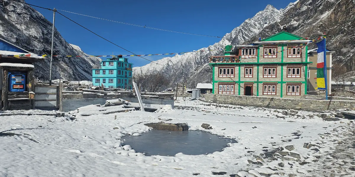
- Syaphru Bensi (1,467 m): This town is the gateway to the Langtang Valley and is close to the Timure/Rasuwagadhi border, used to cross into Tibet. You can find multiple monasteries here that you can visit on the final day of the trek. Since we’ll arrive early, you get the entire afternoon to yourself here, which is more than enough to explore the town, or you may choose to simply rest and relax.
Major Attractions of This Trek
Within this 10-day timeframe, you get to visit 4 UNESCO-listed sites in Kathmandu Valley, explore Langtang National Park, meet one of Nepal's most distinct ethnic Tamang communities, walk beside a glacially-fed Langtang Khola river for three consecutive days, and summit a 4,985 m viewpoint peak!
Now, allow us to explain what each of those experiences actually involves (in order):
A Full-Day Kathmandu Heritage Tour
Nepal has 10 UNESCO World Heritage Sites in total, and 7 of them sit within Kathmandu Valley. You get to visit 4 of them on Day 2 with a government-licensed guide on this itinerary:
- Kathmandu Durbar Square: This is the historic palace complex of the Malla and Shah kings, which is located in Basantapur. The square holds the Kumari Ghar, home of the living goddess Kumari, and also the Hanuman Dhoka Palace Museum. While the 2015 earthquake had damaged several structures here, much of the complex has been carefully restored as of 2026.
- Swayambhunath Stupa: This happens to be one of the oldest Buddhist monuments in the valley, believed to date back to approximately 460 AD based on the Chronicles of Gо-pal. It sits on a hill west of the city and offers the best views across Kathmandu Valley from the top! That’s not just about it. Its iconic all-seeing eyes of the Buddha (painted on all four sides of the tower) is one of the most photographed images in Nepal!
- Boudhanath Stupa: Considered the largest one in Nepal, Boudhanath is in fact the largest spherical stupa in the world and is well-known for being the spiritual centre of the Tibetan Buddhist community. There are over 50 Tibetan monasteries and gompas around the main structure. The main highlight here is kora (circumambulation) that happens throughout the day and can be performed by anyone!
- Pashupatinath Temple: It is one of the holiest Shiva temples in the world, built on the banks of the sacred Bagmati River. The overall temple complex includes the main shrine (not accessible to non-Hindus), but the ghats along the river, where cremation rituals are performed, are open to visitors. You can stay late to watch the Sandhya Aarati ceremony at around 6-7 PM, which is one of the most culturally significant things to witness in Nepal!
A Drive to Remember via Nuwakot and Rasuwa
The 110 km drive from Kathmandu to Syaphru Bensi is where your trip actually begins as you finally start seeing the natural attractions of Nepal. The route heads north through Tokha and into Nuwakot District, where the road follows the Trishuli River gorge for much of the journey.
Just to give you some context: Nuwakot has its own historical significance that most trekkers pass through without knowing. Prithvi Narayan Shah, the founder of modern Nepal, used Nuwakot as one of his key military bases during the unification campaign and was successful in capturing the Kathmandu Valley too.
You will stop near here for tea with your trekking squad before entering another district, Rasuwa, that shares a direct border with China.
The terraced hillsides around Nuwakot grow rice, maize, and millet at lower elevations, and the settlements along the river look remarkably different from Kathmandu's urban density, even though you are only a couple of hours from the capital.
After Betrawati Bazaar, the landscape shifts, with hills becoming steeper and the vegetation becoming thicker. The road begins to climb through landslide-prone sections that are a genuine reminder that this Pasang Lhamu Highway is a Himalayan road, not just any normal highway!
The army checkpoint at Dhunche is where your Langtang National Park permit is processed, and from Dhunche, the final drive to Syaphru Bensi takes less than an hour!
Langtang Glacier, Langtang Khola, and Bhotekoshi River
The river you will walk beside for most of this trek originates from the Langtang Glacier, the longest glacier in the Langtang region, which itself is fed by Langtang Lirung (7,234 m).
The Langtang Glacier stretches approximately 18 km and spans an area of roughly 46.5 sq km between altitudes of 4,500 m and 7,000 m. The meltwater from this system feeds the Langtang Khola continuously throughout the year!
At Syaphru Bensi (1,467 m), this Langtang Khola meets the Bhote Koshi River, whose origin is the Zhangzangbo Glacier in Tibet and enters Nepal through the Rasuwagadhi border.
On the trail, you walk beside clean, fast glacial water for most of Days 3, 4, and 7! The sound of the Langtang Khola carries through the forest all the way from Syaphru Bensi to Kyanjin Gompa.
At Bamboo and Lama Hotel, your teahouse sits right on the bank. You might want to plunge in or drink water directly, but do not do either!
Meet Tamang Community from the Very Start
According to the 2021 Nepal Census, Rasuwa District has a total population of 46,689 people, of whom 68.78% are Tamang (29,782). This makes them the dominant community across the entire district and even the largest in Bagmati province (with a population of 1,216,517)!
The district name itself comes from the Tibetan words "ra" (lamb) and "sowa" (grazing), a reference to the historical role of highland herding that the Tamang communities practised across these hills for centuries!
The Tamangs are historically of Tibetan origin and arrived in this region from across the northern passes. Their language (Tamang), religious practice (Tibetan Buddhism), and material culture are very distinct from those of the Hindu communities.
The good news is that you will meet them at every stop from Syaphru Bensi to Kyanjin Gompa. The teahouse families, the lodge owners, the guides and porters, and even the farmers in the fields beside the trail are all Tamangs.
The major festivals celebrated by people in Langtang are Sonam Lhosar (Tamang New Year, celebrated in mid-January), Gyalpo Lhosar (Tibetan New Year, mid-February in the higher Langtang Valley), Mani Rimdu (late October to early November), Dumji (June to July), and Dhukpu Cheju (around July).
If your trek dates fall near any of these, the atmosphere in Kyanjin Gompa and the valley villages is noticeably different and worth planning around!
Furthermore, Tibetan Buddhist culture is present at every step along the Langtang Trek route. Mani walls, which are long stone walls inscribed with the mantra Om Mani Padme Hum, are available from Syaphru Bensi onward.
Also, you get to see prayer wheels, chortens, and prayer flags appear at every village entrance and trail junction. Don’t worry! The included guide from this package will explain these before you even start walking.
Langtang and Jugal Mountains Visible Along the Trail
The mountain views on your Langtang trek build up as you gain elevation, rather than appearing all at once. You get proper glimpses of Langtang Lirung from Lama Hotel on a clear morning, but the real opening of the panorama begins after Ghoda Tabela:
- From Langtang Village (3,455 m): Langtang Lirung (7,234 m), Langtang II (6,571 m), Luri Himal (6,924 m), Pangshungtramo (5,262 m), Gochenpo (5,296 m), Boden-Powell South Peak (5,857 m).
- From Kyanjin Gompa (3,890 m): All of the above, plus Tsergo Ri / Tserko Ri (4,985 m) directly above the village, Ganchenpo (6,378 m), Pongen Dokpu (5,928 m), Dshabu Ri (4,943 m), Kanja La Chuli (5,652 m), Ghanja La Chuli / Naya Khanga (5,863 m), and Donagpo (4,992 m).
From the two viewpoints above Kyanjin, the panorama expands further in both directions:
- From Kyanjin Ri (4,700 m): All Kyanjin Gompa peaks, plus Kimshung/Tsangbu Ri (6,781 m), Yubra Himal (6,048 m), Yansa Tsenji (6,567 m), Salbachum (6,707 m), Bhemdang Ri (6,150 m), Bhemdang Karpo (6,865 m), Yala Peak (5,732 m), and Yala Peak South (5,520 m).
- From Tsergo Ri (4,985 m): Everything visible from Kyanjin Ri, plus Ramthang Karpo Ri (6,865 m), Langhisha Ri (6,412 m), Gurkarpo Ri (6,891 m), Loenpo Gang (6,979 m), Dorje Lhakpa (6,966 m), Kanshurm (6,078 m), and Urkenmang (6,150 m).
Let’s learn more about the two viewpoints below.
The Hike to Kyanjin Ri
On Day 5 of this 10-day itinerary, you reach Kyanjin Gompa by around midday. After lunch, the afternoon is dedicated to the Kyanjin Ri hike, timed specifically for the evening light.
The trail begins from the east side of Kyanjin village and climbs immediately on a steep, direct path up the ridgeline.
The lower viewpoint, Lower Kyanjin Ri (4,300 m), is 1.5 km from the village and takes about 1.5 hours to reach. Langtang Lirung appears directly ahead, the Lirung Glacier is visible right beneath it, and Kyanjin Gompa village sits on the other side.
For trekkers who are feeling the altitude or prefer a shorter summit, this viewpoint is already a significant achievement. But to those who wish to continue to the main summit of Upper Kyanjin Ri (4,700 m), you add another 1 km of gradual ridge climbing from the lower viewpoint, which takes about an hour more.
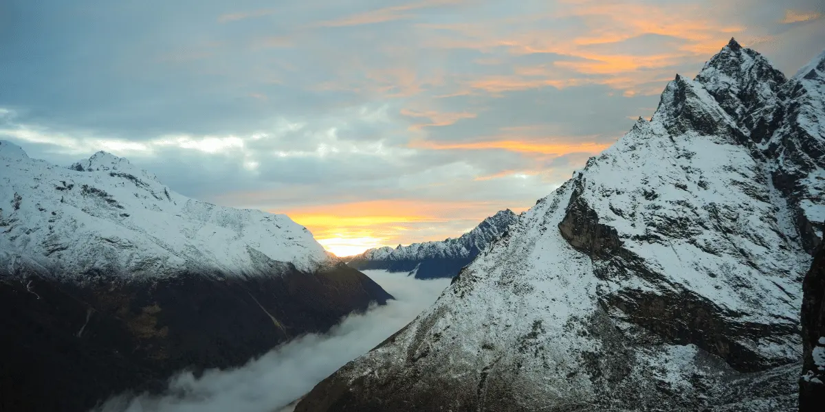
The sunset from here (when weather conditions cooperate) is one of the best photographs you will take on this trek for sure!
You see, it is going to be a demanding afternoon following a long walking day from Thangshyap, but the two-night stay in Kyanjin means you have a full rest before Tsergo Ri the next morning.
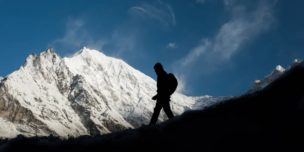
Reaching Tsergo Ri: The Ultimate Summit of This Trek
Tsergo Ri (4,985 m) is the highest point you will reach on this 10-day itinerary, is the most demanding day of the entire trip, and is also one of the best attractions of the Langtang NP!
The trail heads north from the village into the glacial valley, and you will gain approx. 1,110 m of elevation over roughly 5 km to the summit. Above 4,000 m, the terrain can be icy and snowy regardless of season, so crampons are necessary for the upper sections (can be rented from the teahouse if needed).
The elevation gain from Kyanjin to the summit is constant but not technical. There is no climbing involved. What makes it hard is the altitude!
At 4,500 m and above, even slow, steady walking demands noticeably more from your lungs than the same gradient at lower elevations. Most trekkers take 4 to 5 hours to reach the summit and 2 to 3 hours for the descent, which makes a total of 7 to 8 hours round trip.
But what you see from the top is definitely worth the distance you’re covering! The summit is wide enough to sit comfortably, so be sure to enjoy and take tons of pictures here.
But remember to descend before noon. That’s because afternoon winds in the glacial valley can be significant, and the upper trail becomes more difficult to navigate in wind!
Now that you have a full picture of what this trek involves across every stage, from the streets of Kathmandu to the top of Tsergo Ri, let’s go through the day-by-day itinerary below for the specific route, distances, and elevation data for each of the 10 days.
 1317 M
 3 Star Hotel